Summary
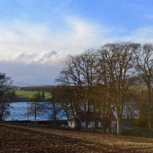
This cycling tour takes you toward the eastern boundary of the Cateran Ecomuseum and around the pretty Loch of Lintrathen, an important reservoir of water for the City of Dundee. Its wildlife reserve attracts vast numbers of wintering wildfowl and there are two excellent cafes along the way for refreshments, the Wee Bear Cafe and Peel Farm.
Scottish Outdoor Access Code: Know the code before you go
Please use the arrows on left/right side to go to previous/next route.
You can download our booklet, From Deep Time To Our Time, Cycling Across The Cateran Ecomuseum here.
Route Stats
Suitable for: Road bikes
Total Distance: 26.1 km
Total Ascent: 300 m
Terrain: A mixture of quiet roads, all on tarmac
Access: Fully accessible with no gates
Route Category: Straightforward
Riding Time: 1 - 2 hrs
Start/Finish: Alyth Market Square
OS Grid Ref: NO 24612 48519
Nearest Parking: At the start
Key Facilities on Route: Alyth (accommodation, shops, restaurants, cafes), Peel (cafe & farm shop), Brigdend of Lintrathen (cafe)
OS Landranger Map: 53 (or custom Cateran Ecomuseum map)
For information on local accommodation & services click here


Route Description
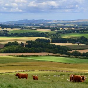
The route starts in Alyth’s historic Market Square. It follows Commercial Street first, then up the famous ‘Toutie Street’ before taking a right turn onto Meethill Road (B952). As you leave the town you can visit one of the many prehistoric standing stones in the area. After about 750m the road forks, and the route continues on the right eastbound. After about 4km the route passes a bridge across the River Isla, one of the main tributaries of the River Tay, with a T-junction shortly afterwards. Here the route continues left, up a relatively steep incline, for about one kilometre through beautiful Beech trees, part of the ancient Airlie Estate. The route follows the road that turns sharply to the right. After about another kilometre the route follows a road to Bridge of Lintrathen, where the Wee Bear Cafe is a great place to stop.
The route follows the road to the right around the loch to a four way crossroads, look out for one of the entrances to the wildlife reserve on your left. Take a left here (another entrance to the wildlife reserve is on your left) to continue along the shores of the loch. Shortly afterward the route takes a right turn onto another road, which passes another refreshment stop, Peel Farm. Follow the signposts back to Alyth past one of Scotland’s most dramatic waterfalls, Reekie Linn.
Find out more about some of the key Points of Interest below.
If you enjoyed this route, why not try the following?
Points to visit
Along the way you will find these points of interest:

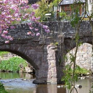
Pack Bridge
One of the oldest masonry bridges in Scotland. Alyth’s Pack Bridge (intended to carry packhorses loaded with sidebags or panniers across the burn) is one of the oldest masonry bridges in Scotland and is shown on maps as far back as 1600. Reputedly...
Read more - "Pack Bridge"Toutie Street
A permanent reminder of a bygone custom. This street name immortalises the bygone custom of the herdsman tooting his horn, alerting the townsfolk to bring out their beasts to be herded up Alyth Hill. The deeds of over 200 properties in the old town...
Read more - "Toutie Street"Market Cross
A monument from Alyth’s ancient trading history. The erection of a Market Cross or ‘Mercat Cross’ in Scotland served as a symbolic representation of the right to hold a regular market or fair. This right was granted to settlements awarded...
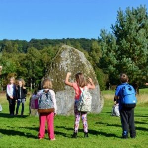
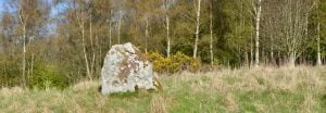
Read more - "Market Cross"Pitcrocknie Stone
A fine example of a late Neolithic or early Bronze Age Standing Stone. Travelling out of Alyth on the B952, on the right hand side of the road, a few yards after the last old red sandstone house in the town, lies a new housing development. The...
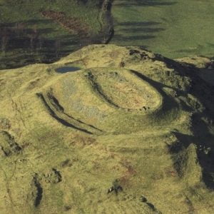
Read more - "Pitcrocknie Stone"Barry Hill Fort
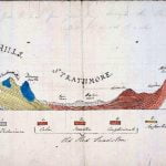
One of the best preserved examples of an enclosed hilltop settlement in Scotland. Viewable from across Strathmore and from the roads around Alyth, Barry Hill fort has not yet been excavated. However, similar monuments elsewhere have been found to...
Read more - "Barry Hill Fort"
The Drumderrach Stone
Prehistoric Standing Stone with magnificent views. Just on the eastern field boundary where the Shanzie Souterrain lies, on the other side of the hedge, is a wide grassy path leading steeply up to this spectacularly positioned standing stone. A...
Read more - "The Drumderrach Stone"The Shanzie Souterrain
An Iron Age underground structure. Souterrain (from the French ‘sous terrain’, meaning ‘underground’) is the archaeological name for a type of underground structure associated mainly with the European Atlantic Iron Age that may have been...
Read more - "The Shanzie Souterrain"Lintrathen Wildlife Reserve
A tranquil sanctuary for wild birds. The beautiful inland Loch of Lintrathen has supplied the city of Dundee with water since 1875. Water is fed down from the Backwater Reservoir 4km to the north, leaving the Loch through sluices at Bridgend of...
Read more - "Lintrathen Wildlife Reserve"Durwards’ Dike
A medieval Deer Park. As you turn south, half way down the western flank of the Loch of Lintrathen, if you look at the OS maps, the remains of Durwards’ Dike are marked. This is believed to have been a Deer Park in the 13th century. Hunting...
Read more - "Durwards’ Dike"