“Landscapes provide a living history of Scotland’s past and inspiration for many aspects of our culture. They underpin our national economy and offer a wide range of social and health benefits. We must look after our landscapes as a unique and irreplaceable resource for current and future generations.” Nature Scot
During 2023 and 2024, local people involved in our River Detectives programme told four remarkable stories of how humans have intervened in the landscape of Strathmore in the past. Each investigated how the people of Strathmore managed their rivers, bogs and lochans through the agricultural and industrial revolutions 1700-1900 and how this knowledge might help local communities take better care of them now and in the future.

Strathmore from Dunsinane Hill, photo Clare Cooper
Flax & Flood: An Environmental History of the Blairgowrie Mills, looked at how the environment affected the mills – and vice versa. How did changing 19th century weather patterns affect the mills? What were the effects of extreme weather (floods, droughts) on them? How did the mills manage the water supply? Was steam-power a response to variable water supply? How did the mills work together and compete over the water supply? How did they work and compete with other users of the water supply: farms, traditional mills, salmon fishing and the town itself?

Digging out a lade on the River Ericht in 1932, photo Laing Collection
Flood & Flow: Reconstructing Flood Histories for the River Isla, aimed to extend the flood history of the river beyond 19th century written records using geological techniques, by sampling and recording sediment samples, identifying numbers and magnitudes of floods, dating them using scientific techniques, explaining them in terms of climate and land use change, placing the floods of the last several years in an historic context, and making the data available to local communities and professional users.

Reekie Linn Falls, River Isla, photo George Logan
Peat & Productivity: Discovering a lost landscape around Meigle. Old maps indicate that the flat ground between Coupar Angus and Eassie was covered in wetlands before the 19th century. This project used many different types of evidence, historical and archaeological, to establish what was there, how extensive it was, how and why it disappeared, what replaced it, and what, if anything, is still there to be discovered.

Engraving by George Heriot Swanston of Patrick Bell’s reaping machine
Marl Mania: Exploring the basis for the 18th century agricultural revolution in Strathmore. A few contemporary descriptions make it clear that landowners after AD1730 destroyed many peat bogs and lochs to find marl, a powdered limestone, to put on their fields and increase outputs. But we have almost no idea, in Strathmore or in Scotland, how the whole process worked, from finding the marl, to organising and funding how to get it, the mechanics of quarrying it, what was done with it and what the legacy of all this was. This project began to find out.
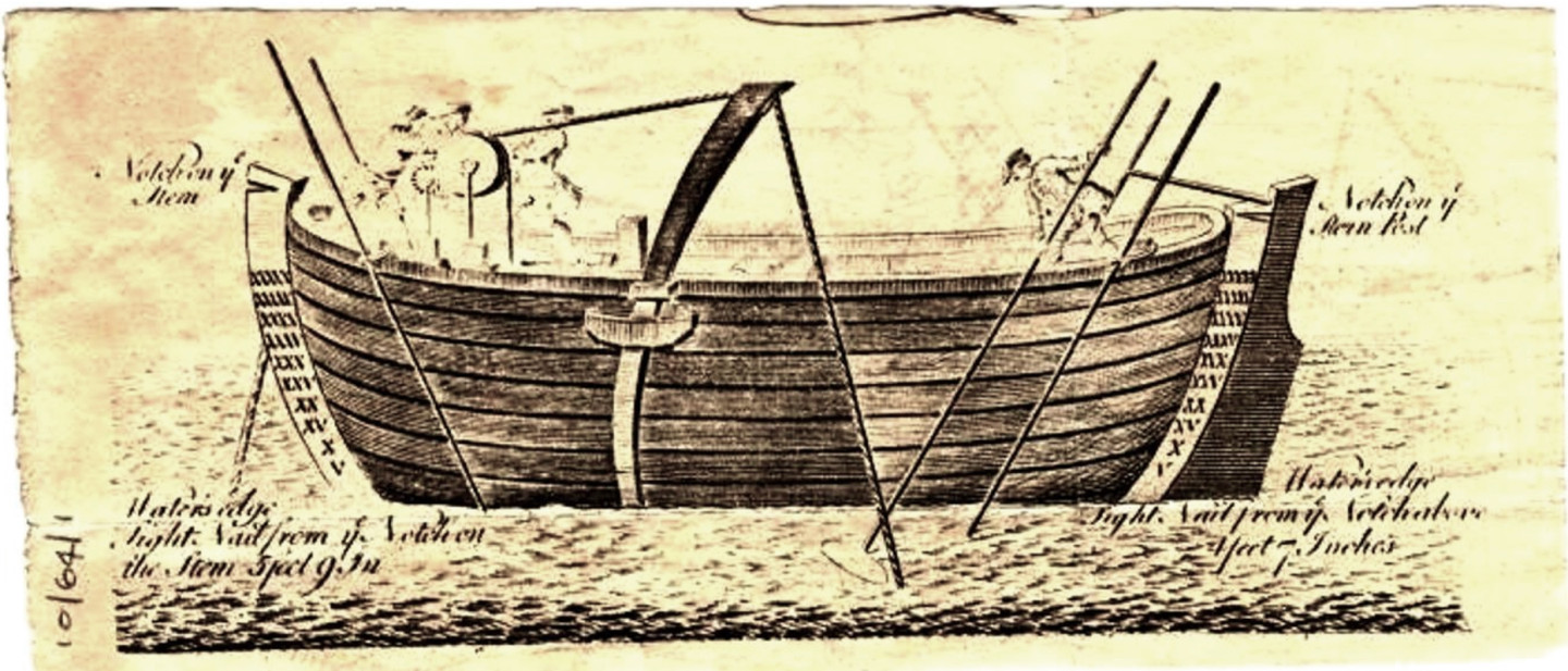
Drawing and dimensions of Marl Boat used by Mr Watson on Rescobie Loch, image courtesy of Angus Council Collections cared for by ANGUSalive Museums, Galleries and Archives
You can also download this digital booklet version.